th2ombre
It's ALWAYS about the light
All in a day’s work
Posted on August 3, 2018
KSFO San Francisco International
Some backstory is needed for this. On Wednesday my airplane owner partner, Mason, slammed at his SwimLabs business, asked if I could help by returning a tech consultant named Al that he’d brought down from the Bay Area. Let’s see, a fair weather day, and my professional aviation chops are needed to fly to San Francisco? Oh, twist my arm.
This provided another opportunity—I brought along Anke Boschman, the UCSD foreign exchange student from the Netherlands whom we hosted when she came in-country a few months back. She’ll be heading back to Europe soon, so this was a chance to show her a bit of the Golden State, and what U.S. general aviation looks like. And she could help keep an eye peeled for other airplanes in this state’s busy airspace.
Al was down as a tech geek, but he’s doing graduate work in paleontology, studying mass extinction events, only one of about a dozen of which is the famous dinosaur version. Anke is doing graduate research developing models in her fields of bio fluid dynamics and structural engineering, all with an eye to improving human heart valve transplants. Talk about a couple of brainiacs. While engaging them aloft, I tried not to drool while blurting high-end aviation stuff like “we try to keep the pointy end pointed over there by that whats-its.” The en route conversation was entertaining, with me occupying the bottom of the totem pole.
We were able to make the flight up and back operated visually, which provided the possibility of what is known very technically as the San Francisco Bay Tour. Right. Our landing destination, in avoidance of the bazillion dollar landing fees at SFO, was the San Carlos (KSQL) aerodrome 8 nautical miles SE of San Francisco International. The control boundaries of the two aerodromes abut, which is a key element in this adventure. When the weather allows, and SFO’s traffic levels permit, the San Francisco tower controllers are known to allow overflight through their airspace in passage to The City (as San Franciscans love to say), and then over the bay, where a turn can be effected to pass the Golden Gate Bridge, then sashay down the coastline SE-bound to return to wherever (Carlsbad Palomar airport in north county San Diego).
Another piece of the puzzle needs explanation. Very busy commercial airports like San Francisco, have designated from their centerpoint what is known as Class B (Bravo, in pilotspeak) airspace. To describe Class B airspace it is commonplace to say it is like an upside down wedding cake, with the topmost and smallest diameter part of the inverted cake resting on the center of the (SFO, in this case) airport surface and going up to 10,000′ MSL. The next layers below on what would be a real upright cake, are above in the Class B, with a floor of maybe 1,500′ and the top at 10,000′. This layer would begin a few miles out from the hub centered over the airport. The next layer farther out might begin at 3,000′ and go to 10,000′, and so on. Picture that inverted layer cake, and you’ll get the idea. All of this allows aircraft descending to the aerodrome or climbing out from it to stay in protected “B” airspace both vertically and laterally. Naturally this only works if the airliners stay within the cake material and the other folks stay out of it. Unfortunately, each successive layer isn’t completely round, but composed of all sorts of arbitrarily shaped cake pieces, with equally irregular floor altitudes. Lots of convolutions, and none of this is depicted with yellow tape lines aloft, so considerable three-dimensional awareness, a good aviation chart, and an über accurate flight management system (aircraft computerized navigational system) are essential to staying clear of the wedding cake’s innards. Guess I forgot to mention that thou shalt not enter Class B airspace without ATC’s blessing, lest one sees their airman certificate snatched from thine grubby fingers?
So how this particular event played out was during taxi out, my requesting of the ATC tower at San Carlos if they would ping SFO tower for their blessing to transit in furtherance of our lark? They came back with a transponder code, the SFO tower frequency I should expect to use, and the admonition to not get into the SE portion of the KSFO surface-based Class B 1 nm beyond the departure end of SQL’s runway 30 without first getting SFO’s authorization on said frequency. Our takeoff would be bore-sighted on SFO, and I’d have literally seconds to switch from SQL’s tower frequency and make contact on SFO’s busy frequency to receive clearance to enter their “B”. No pressure, right?
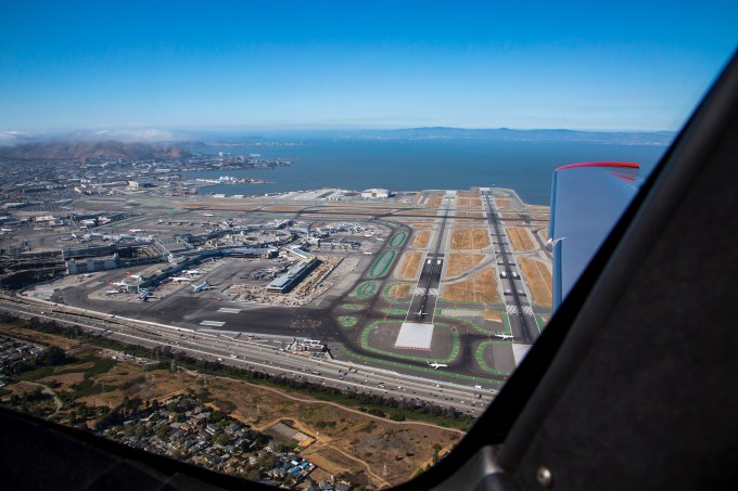
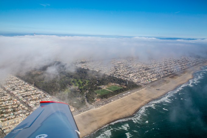
The picture above is from about 90 seconds after liftoff. Quite the view. I had just leveled at 1200 feet, westbound, and you’re looking due north at SFO’s runways 01L and 01R. These are their preferred takeoff runways for most operations, with the cross runways (28L and 28R) used for landings and heavy-weight international takeoffs. A little background to any delays you may have had in SFO flights before. The prevailing winds at SFO are out of the west, favoring runways 28, but still allowing takeoffs on the 01s. But when the surface wind from the west exceeds 14 knots, if memory serves, they go to all operations on just the runways 28. SFO then becomes a two runway airport vs. four. We pilot bums referred to it as the “Rule of Two” for delay expectations—two clouds, or two runways, expect delays. You’re now cognoscenti.

FMS flight plan
This picture shows the cockpit display of the flight management system (FMS) while underway, moments after the picture above was taken. I created the flight plan after engine start, immediately before taxiing out to the runway, based on chart study the day before that this routing would produce the desired sightseeing and stay compliant with airspace restrictions. Anyway, at this point in the air, ATC took pity on me and allowed me to climb from 1200′ MSL to 1800′ MSL to miss some gathering low marine layer stratus clouds pouring over the hills from the west. This altitude would create challenges of sticking my no longer so furry head hairs into the floor of the next layer of overhanging Class B as I exited the surface-based “B” heading away from KSFO, but I had ATC’s authorization, so there. In the right hand screen, the FMS flight plan shows that I’ve departed the SFO01 waypoint (one I created within the computer that was 240 degrees and 2 nm from the center of the airport, in keeping with the ATC admonition to stay south of the Bayshore, i.e., 101 freeway, as I passed KSFO). I’ve just made a slight right turn abeam of where Candlestick Park used to was, and am now headed towards Alcatraz island, which course will take me directly overhead the city center. Oh, yeah, SFO tower also asked if I had the jet rolling on its takeoff from runway 28L? “Good, keep that aircraft in sight.” Towerspeak for midair collisions being very bad form. If you look carefully in the inset map in that screen, you can see the SFO peninsula and a graphic depiction of this short leg of the course as a magenta line (the active leg) to the waypoint I’ve created and called SAU01, which is the SAUsolito navaid 095 degree bearing at 5 nautical miles. Lying under that fix is Alcatraz, where I’ll make a turn westbound to proceed to my next waypoint SAU02 (Sausolito/173 bearing/3 nm fix), a five nautical mile leg that will cross me right over the Golden Gate bridge, and shown in the inset map as a white course slightly south of due west in that North Up map. Then a turn to the south to fly down the west coast of the San Francisco peninsula.
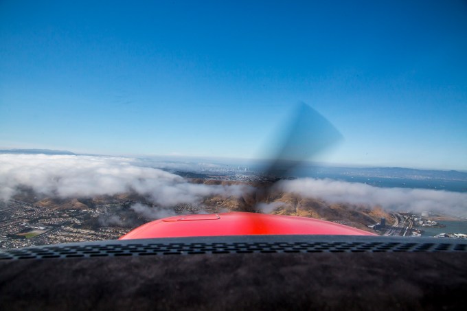
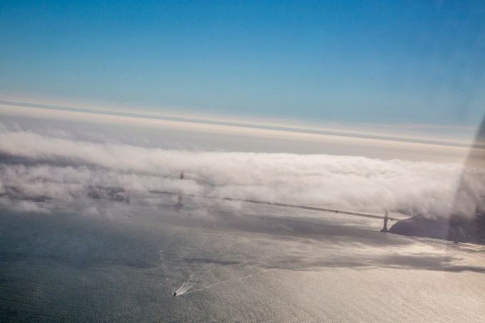
Northbound toward The City and the bay. The low clouds our operating flight rules required me to avoid by specified distances.
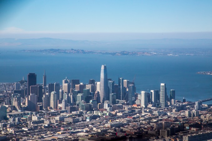
Candlestick to the right, The City at twelve o’clock
Keep your eyes on the prize
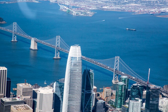
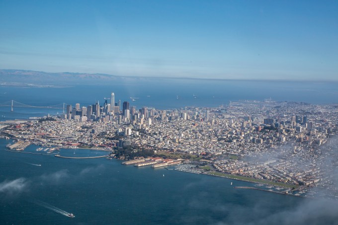
Downtown and the Bay Bridge
Federal aviation regulations also specify criteria for missing buildings and what not. A bit of a dance to comply with that and cloud separation requirements while staying out of the overhanging Class “B” and taking in the sights. No rest for the wicked.

San Francisco columnist Herb Caen’s nemesis on the left
Does this make me the Birdman of Alcatraz?

If you don’t eat your vegetables, or mind your “P’s” and Class Bravos you might end up here.
Finishing the turn towards the SAU02 waypoint t’other side of the bridge thingy.
An over my left shoulder last glance at The City.
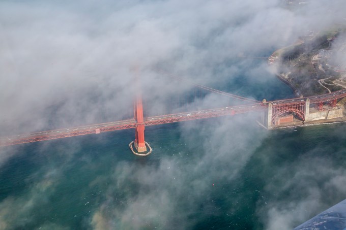
The Jewel
Well, yes, this is certainly my highlight of the bay tour.

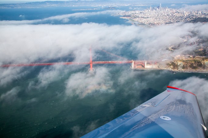
The southern abutment and the Presidio
This particular shot really appeals to me. Reflections on the left wing. And check out the circular rainbow and center dark shadow spot of the light refracting around the plane and projected on the wispy clouds at the lower center of the frame.
You are at the center of the frame just below the bridge stanchion
We’re turning down the coast in the picture above, and as we roll out, there’s the western end of Golden Gate Park.
The finish line of the world’s longest moving block party—the Bay to Breakers—which I ran years back in a pink tutu. Boy did I get rave reviews in the Castro district!
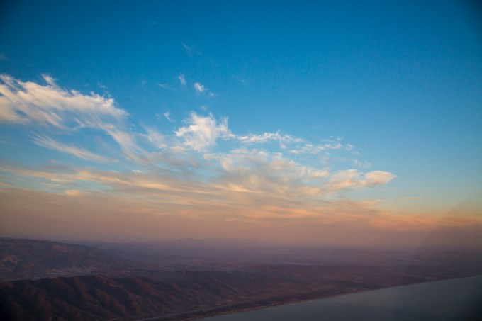
Heading down the west edge of the peninsula, the shore disappeared in the marine layer, so we missed out on seeing the Mavericks surf spot and Halfmoon Bay. The Monterey bay was open, but the coastline was obscured. Monterey’s airport was in the clear, but the community was covered with clouds. Anke got a nice view of Point Lobos, and maybe she’ll share a frame or two of that. The Hunter-Ligget Military Operations Areas were cold (er, inactive in humanspeak) and the R2513 Restricted Area was cold at our 7,500′ cruising altitude. This allowed me to fly the Big Sur portion so that the shore was mostly on Anke’s sightseeing side of the plane.
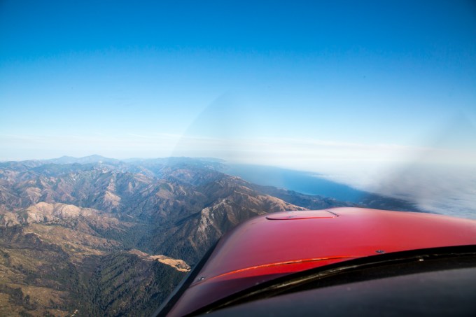
Big Sur coast
I include this image below and as comparison to the one above, to give you an idea of what a sophisticated flight management system flight deck cockpit display our plane possesses. The right screen, known as a Multi-Function Display (MFD) shows the flight plan with its waypoints and their ETAs and fuel status, a moving map with the aircraft position shown on it, and engine instruments on the left margin. This screen can be configured in all sorts of ways to provide useful information to the pilot. The left screen is known as the Primary Flight Display (PFD) which shows a computer-generated view of what you see out the windscreen when you remember to look. (See the picture above of the real world version thereof.) It also conveys the aircraft attitude in relation to pitch and roll, the airspeed, altitude, compass heading, and course guidance. And here, the PFD is also displaying what is called “Synthetic Vision,” i.e., a computer generated display of the actual terrain ahead and below from the worldwide navigational database and the very accurately known GPS position constantly updating in real time. The sort of thing that cruise missiles use to hug valleys below hilltops as they race undetected to their targets. Modern cockpits with displays like this are often referred to as “Glass Cockpits,” with the reference being to the LCD screens of the displays. Long-time pilots of conventional analog displays of 6 instruments showing some of this (called six-pack instrumentation, as well as Jurassic cockpits, or rope-start cockpits) take awhile learning how to use and interpret all the information available in the “glass” flight management system avionics. Once you learn to use them, the tendency is not to go back to old school instrumentation. Young pilots love the computer game similarities, geezers less so. The big difference is that when flying this sort of system a big part of the pilot’s operational mental band-width becomes information management. A negative by-product also tends to be a degradation of basic airmanship skills, and a tendency to get one’s situational awareness of the outside world sucked into the black hole of the avionics. Both of those are avoidable with practice and conscious effort. Years ago at United I developed a seminar introducing glass concepts to pilots transitioning from steam-gauge to glass. What I do instructionally these days is largely helping owner pilots get the most out of their aircraft, its systems and themselves.
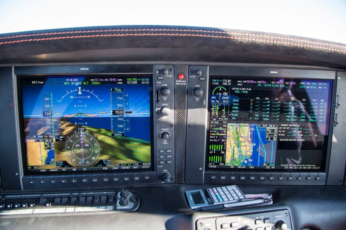
Flight displays over the Big Sur mountains.
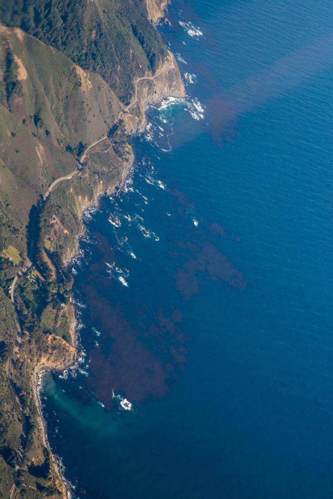
At one point I positioned the plane to steal a glance down on Highway 1.
Okay, here’s a bit of egg-on-my face mea culpa. A few miles south of here, we came upon the Hearst Castle. As we were closing in on it, positioning the airplane so it would be on Anke’s (right) side of the cockpit, I waxed on about William Randolph Hearst’s publishing empire, the massive wealth he aggrandized, Citizen Kane, Orson Wells, “Rosebud” and even Wells’ speaking part in the War of the Worlds radio drama. I had set a course track that would put the castle nearly under the plane on the right side, planning to initiate a steep right bank to do a turn about a point on the castle below for viewing purposes. I couldn’t see it as it was under the right hand floor boards, but, Anke, looking down, allowed as how now was the time to make the turn. Hand-flying with my left hand, I rolled us into the right bank and using my right hand, fired off five quick consecutive frames with the camera held at arm’s length shooting across the cockpit and down the right wing. Splendid. Until when I downloaded the images on our return, I discovered five consecutive completely black frames. Yep, rookie mistake, having forgotten to first take off the lens cap. Obviously my mental bandwidth was still up over the Big Sur coast in an FMS black hole! Duh.
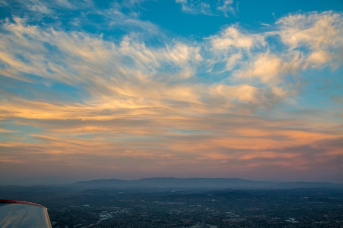
A modest while later we approached the Los Angeles basin from the general direction of Thousand Oaks. Back in the day we whimsically referred to it as “Thousand Pilots” given how many of my LAX-based brethren lived in the enclave. At this point it was getting late in the day, and colors were warming wonderfully.

The Hollywood hills from the north side.
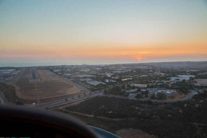
After passing Los Angeles and Orange county it was time to begin descent for our landing at Carlsbad’s McClellan-Palomar airport where our trusty time machine is hangared. I’m proud to say that I’m old enough to have known Jerry McClellan and his son, Jayce. Jerry was a Cherokee Six owner pilot, a true gentleman and a tireless booster of Carlsbad and the value to north-coastal San Diego county of then sleepy KCRQ.
You may have heard that sunsets and sunrises find favor with me? Here’s how our business day ends as we descend and maneuver for the KCRQ traffic pattern and line up for the landing.
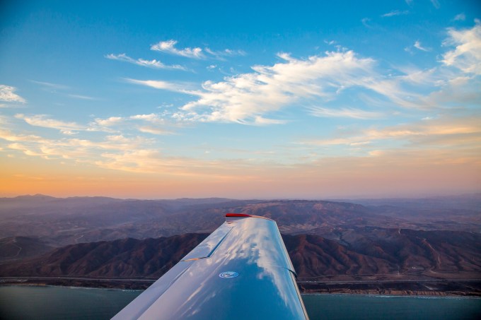
Yes, as a matter of fact, I DO love wing reflections.
In a word—luscious.
Credit Anke for this one, I was a little busy just then.
We rolled on takeoff from KCRQ at 14:12 local time. Two hours and a quarter to San Carlos. Maybe :30 on the ground including refueling, getting the bay tour clearance and building the FMS flight plan to stay legal with the airspace convolutions, and about two hours forty minutes on the return with the extra miles of the tour, and modest headwinds in the bargain. Touchdown exactly at the 19:48 sunset. Just the sort of mission at which general aviation excels, with some wondrous bells and whistles thrown in.
I’m a fortunate person, and I try not to forget it. T

Recent Comments